Case Studies
LiDAR vs. Photogrammetry: Choosing the Right Drone Mapping Tool for Your Golf Course
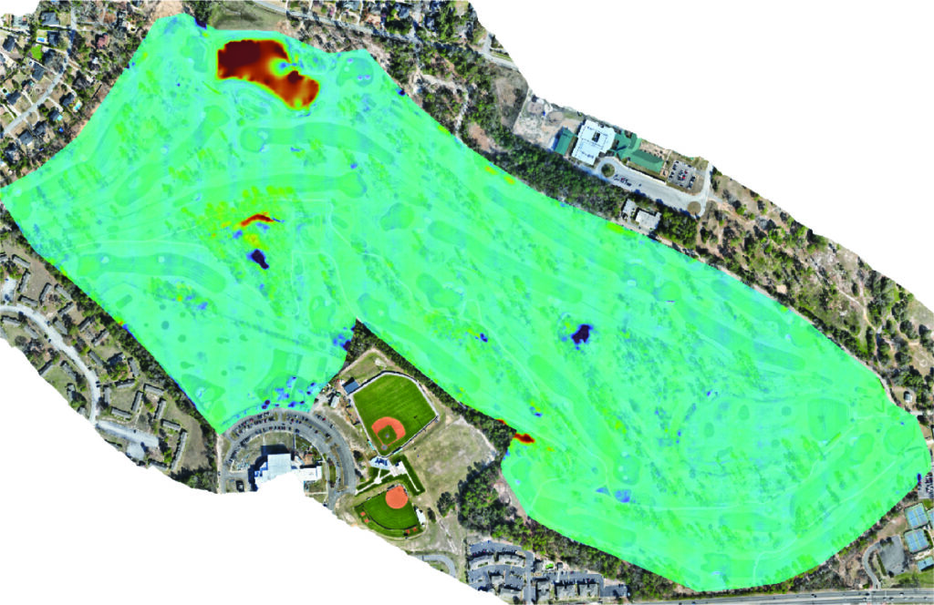
A Head-to-Head Comparison at Forest Hills Golf Course
At SimpliFly, we often get asked: “Which is better, LiDAR or photogrammetry?” The honest answer is, it’s not about which is “better,” but which is the right tool for the job. To show you what we mean, we conducted a side-by-side comparative analysis at Forest Hills Course, putting both technologies to the test.
While both LiDAR and photogrammetry generate similar 3D geospatial data, they have distinct strengths and weaknesses. Let’s break them down.
Understanding the Technologies
First, let’s cover the basics in simple terms.
- LiDAR (Light Detection and Ranging): Think of LiDAR as using a laser to measure distances. It’s an active technology that sends out pulses of light and measures how long they take to return. Its superpower is the ability to penetrate through dense vegetation like tree canopies to map the ground underneath. However, LiDAR on its own just measures distance; it doesn’t create a visual image or basemap. It also tends to have a higher cost compared to photogrammetry.
- Photogrammetry: This is a passive technique that uses thousands of high-resolution images captured by a drone. By analyzing pixels and using precise drone location data, specialized software stitches these images together to create a detailed and visually stunning 3D model. Photogrammetry excels at creating imagery basemaps and mapping open areas with high accuracy. Its limitations appear in densely vegetated areas or over uniformly textured terrain—like sand.
The Face-Off: LiDAR vs. Photogrammetry on the Green
When mapping a golf course, the results from both technologies are often comparable, but a few key differences emerge.
- The Bunker Challenge: A sand bunker’s uniform appearance can pose a challenge for photogrammetry’s vertical modeling. While horizontal accuracy remains high, the software can have trouble perfectly reconstructing the bunker’s depth and shape. LiDAR, with its direct laser measurements, captures this detail with greater raw accuracy. That said, these minor photogrammetric discrepancies can be significantly reduced with professional data cleaning and smoothing algorithms.
- Trees & Shadows: Trees can be an obstacle for photogrammetry, especially for tee boxes tucked away in wooded areas. Shadows cast across fairways or greens can also introduce small errors. In both of these scenarios, LiDAR holds a clear advantage, as it can effectively bypass these obstructions.
The Verdict: Balancing Performance and Cost
Our analysis at Forest Hills revealed that the average difference in elevation data between the two technologies was around -0.05 meters, excluding ponds and forested areas.
So, what’s the best strategy for your project?
The optimal choice comes down to balancing cost-effectiveness with your specific data needs. Our findings show that photogrammetry sufficiently addresses about 90% of golf course mapping requirements at a lower cost. It delivers excellent results for most applications.
However, if your project demands the highest possible data quality, especially for precise bunker reconstruction or mapping terrain beneath dense tree canopies, a hybrid LiDAR approach is the superior option. While it involves a higher cost and greater operational complexity, it delivers an enhanced level of detail in these challenging areas.
At SimpliFly, we’re here to make data simple. We help you weigh these factors to make a confident, informed decision that aligns with your goals and budget.
Check out our report for full data analysis and helpful visuals!