Building Smarter: How Drone Data Elevates Accuracy, Efficiency, and Safety in AEC Projects
I. Introduction: The Evolving AEC Landscape
The Architecture, Engineering, and Construction (AEC) industry operates under constant pressure to deliver complex projects on time and within budget. However, traditional workflows often face significant hurdles: project delays and cost overruns are common 14, coordination among diverse teams can be challenging, site safety remains a paramount concern 15, and obtaining accurate, comprehensive site data for initial planning and design is often time-consuming and expensive.16 Conventional surveying methods, while reliable, can be slow, labor-intensive, costly, and pose safety risks, especially in hazardous or difficult-to-access terrain.17
In this dynamic environment, Unmanned Aerial Vehicles (UAVs), or drones, are emerging as a transformative technology. Drones are rapidly moving beyond niche applications to become integral tools that enhance project performance, boost productivity, mitigate risks, improve quality, and lower operational costs across the entire project lifecycle – from initial site analysis and design through construction monitoring to final documentation and handover.15 They are redefining how AEC professionals approach site analysis, inspections, surveying, and project documentation.16A critical advantage drones offer is their ability to efficiently bridge the gap between the digital realm of design (Building Information Modeling – BIM, Computer-Aided Design – CAD) and the physical reality of the construction site. By capturing frequent, accurate snapshots of the as-built conditions, drones enable proactive verification against design models.14 This early identification of discrepancies between the plan and the execution is crucial for preventing errors that can lead to significant delays and costly rework.14 Furthermore, the comprehensive and easily shareable visual data captured by drones – detailed maps, 3D models, high-resolution photos, and videos – fosters vastly improved communication and collaboration among architects, engineers, surveyors, contractors, and clients.10 This shared understanding, based on objective site data, minimizes misunderstandings, reduces potential disputes, and contributes to smoother, more efficient project execution. SimpliFly provides the expertise and technology to harness this aerial intelligence, empowering AEC professionals to build smarter, safer, and more efficiently.
II. The SimpliFly Advantage: Precision Data for Every Phase
Partnering with SimpliFly for drone data acquisition and analysis delivers substantial benefits throughout the AEC project lifecycle, addressing key industry pain points with precision and efficiency.
- Speed & Efficiency: Drones dramatically accelerate data collection. Large sites that might take days or weeks for traditional ground crews to survey can often be mapped by a drone in a matter of hours.17 This speed extends to progress monitoring and inspections, providing rapid updates and reducing fieldwork time.24
- Cost-Effectiveness: By reducing the need for extensive manual labor, specialized surveying equipment, and access machinery like lifts or scaffolding, drones significantly lower the costs associated with surveying, mapping, inspections, and progress tracking.18 Real-world construction case studies demonstrate tangible ROI, with reported savings in inspection times (up to 60%) and labor costs (20-30%).24
- Enhanced Safety: Safety is paramount in AEC, and drones offer a major advantage by eliminating the need for personnel to physically access dangerous or hard-to-reach locations.15 This includes working at height on structures or scaffolding, navigating hazardous terrain, entering confined spaces, or working near active machinery or traffic. Reducing human exposure to these risks improves worker safety and minimizes liability.24
- Improved Accuracy & Data Quality: Modern drones equipped with advanced sensors and GPS technology (including RTK/PPK for enhanced precision) can achieve survey-grade accuracy, often reaching centimeter-level precision, rivaling or surpassing traditional methods.18 They capture comprehensive, high-resolution data points across the entire site, providing a much richer and more detailed dataset than point measurements taken manually.20
- Versatility: Drones are highly adaptable tools. By equipping them with different types of sensors, SimpliFly can tailor data collection to meet diverse project needs throughout the lifecycle, from initial topographic mapping to final as-built documentation.20
SimpliFly leverages the right technology for the specific AEC task:
- High-Resolution RGB Cameras (Photogrammetry): This technique uses sophisticated software to process hundreds or thousands of overlapping aerial photographs captured by a drone’s RGB camera.14 By identifying common points in multiple images, the software can reconstruct the scene in 3D, generating detailed, textured 3D models and high-resolution, map-accurate 2D orthomosaics. Photogrammetry is often a cost-effective solution for visual progress monitoring, site mapping, and creating realistic 3D visualizations.27
- LiDAR (Light Detection and Ranging): LiDAR sensors mounted on drones emit rapid pulses of laser light and measure the time it takes for the light to reflect off surfaces and return.20 This directly measures distances, creating a dense “point cloud” of highly accurate 3D coordinates. LiDAR excels in capturing precise elevation data, modeling complex structures, and penetrating vegetation to map the true ground surface beneath tree canopies.30 It offers exceptional precision, often required for detailed topographic surveys and engineering design.27
- Thermal Cameras: These sensors detect infrared radiation (heat) emitted by surfaces.34 In AEC, thermal imaging is invaluable for building envelope inspections, identifying areas of heat loss due to poor insulation, detecting moisture intrusion behind walls or under roofing membranes (as wet materials often have different thermal properties), and locating potential electrical faults in building systems.34
Critically, the choice between these technologies isn’t always mutually exclusive. Photogrammetry provides rich visual context, while LiDAR delivers superior geometric accuracy, especially in challenging conditions like dense vegetation. The optimal approach often depends on the specific project requirements, budget constraints, desired level of accuracy, and site conditions. SimpliFly provides expert consultation to guide clients in selecting the most effective and efficient technology mix for their unique needs, ensuring the data collected precisely matches the project objectives.27
III. Transforming AEC Workflows: Key Drone Applications
Drone technology integrates into and enhances nearly every phase of an AEC project. SimpliFly offers tailored services leveraging these applications:
A. Site Surveying, Topographic Mapping & Land Analysis
- How it Works: Drones equipped with high-resolution RGB cameras (for photogrammetry) or LiDAR sensors rapidly fly over the project site, capturing comprehensive aerial data.18 This raw data is then processed using specialized software to generate highly accurate and detailed geospatial deliverables. These include 2D orthomosaic maps (geometrically corrected aerial images), Digital Elevation Models (DEMs) showing surface heights, Digital Terrain Models (DTMs) representing the bare earth elevation, contour lines illustrating topography, and dense 3D point clouds (especially from LiDAR).20 Techniques like Real-Time Kinematic (RTK) or Post-Processed Kinematic (PPK) GPS, often combined with Ground Control Points (GCPs), ensure survey-grade accuracy, potentially reaching sub-centimeter levels with LiDAR.20 LiDAR’s ability to penetrate vegetation is particularly valuable for accurately mapping ground levels in forested or overgrown areas.30
- Benefits: This process is significantly faster and more cost-effective than traditional ground-based surveying methods, especially for large or complex sites.16 It provides architects, engineers, and planners with a complete and accurate understanding of existing site conditions – topography, drainage patterns, vegetation cover, existing structures – crucial for informed site selection, feasibility studies, and efficient design.16 Data collection is safer, eliminating the need for surveyors to physically traverse hazardous terrain.20 The detailed elevation data is essential for accurate grading plans, cut-and-fill volume calculations (see Blog 5), drainage design, and overall site suitability assessment.5
- Deliverable: Orthomosaic Maps (GeoTIFF), DEMs/DTMs, Contour Maps, LiDAR Point Clouds (.LAS,.E57), CAD-compatible files (DXF, DWG, XML).12
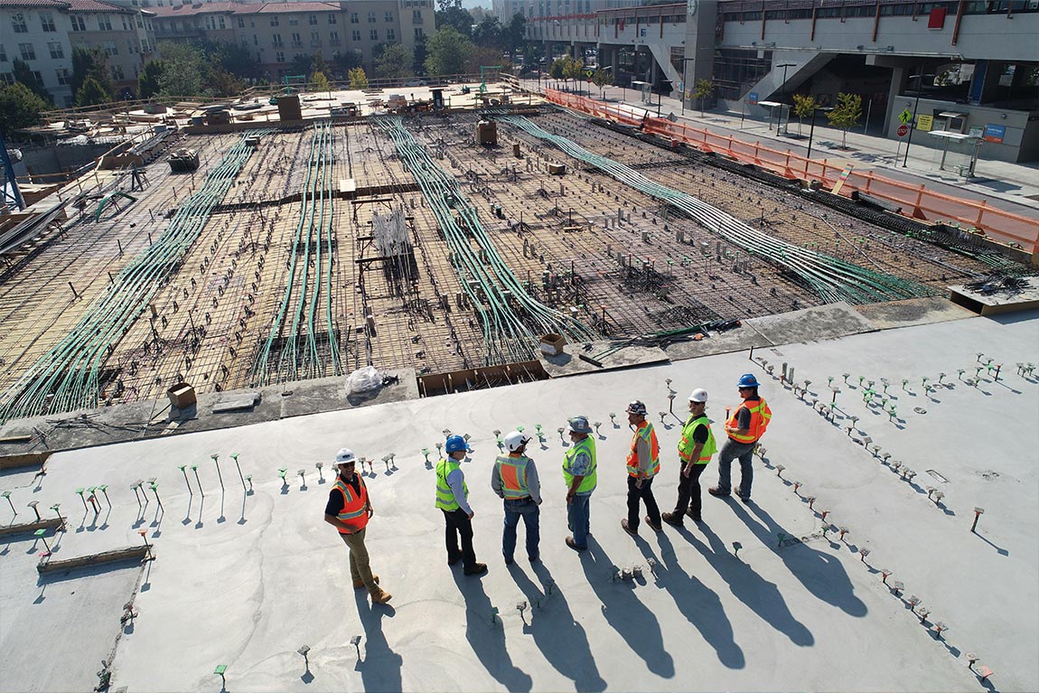
B. Construction Progress Monitoring & Documentation
- How it Works: SimpliFly conducts scheduled drone flights (e.g., weekly, bi-weekly) over the active construction site, capturing consistent, high-resolution photos and videos according to a pre-defined flight plan.15 This data is processed quickly to generate time-stamped orthomosaics and 3D models of the site’s current state.10 Crucially, these current site models can be overlaid with design plans (BIM or CAD files) within software platforms, allowing for direct visual comparison between the planned design and the actual work completed.14
- Benefits: This provides project managers, clients, and other stakeholders with regular, objective visual updates on progress without requiring frequent site visits, saving time and travel costs.10 Comparing the as-built drone data against the design plans allows for the early identification of deviations, potential clashes, or construction errors, enabling corrective action before they become major problems that cause delays and significant rework costs.14 Drone data aids in optimizing site logistics, tracking material placement, and improving overall workflow efficiency.24 The sequence of drone captures creates an invaluable, indisputable historical record of the construction process, useful for verifying work completion, resolving disputes with contractors, and documenting compliance.16 It can also enhance site safety monitoring by identifying potential hazards from an aerial perspective.22
- Deliverable: Dated Orthomosaic Maps, Time-Lapsed 3D Models, Progress Reports (often with annotated images/videos), Comparison Views (As-Built vs. As-Designed Overlays), Site Photos/Videos.
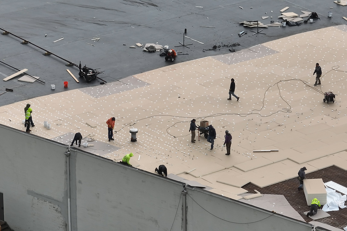
C. Structural & Facade Inspections
- How it Works: Drones equipped with high-resolution RGB cameras, and often thermal cameras, are flown close to building envelopes, bridges, towers, wind turbines, and other infrastructure to capture detailed visual and thermal data.15 Thermal imaging detects temperature differences that can indicate subsurface issues like moisture intrusion, insulation deficiencies, air leaks, or malfunctioning electrical components.34 For applications requiring highly precise geometric measurements of structural elements, LiDAR-equipped drones can capture detailed point clouds representing the exact shape and dimensions.38
- Benefits: Drone inspections are significantly safer, faster, and often more cost-effective than traditional methods that require personnel to use scaffolding, aerial lifts, rope access, or cranes.20 Drones can easily access areas that are difficult, dangerous, or impossible to reach manually.30 This allows for the early detection of structural defects such as cracks, spalling, corrosion, water damage, loose components, or thermal anomalies, enabling preventative maintenance before minor issues escalate into major failures.34 The detailed data captured provides objective information for condition assessments, maintenance planning, and repair prioritization.30
- Deliverable: High-Resolution Annotated Photos/Videos pinpointing defects, Detailed Inspection Reports, Thermal Maps (often with corresponding visual images), 3D Models or Point Clouds documenting structural geometry.
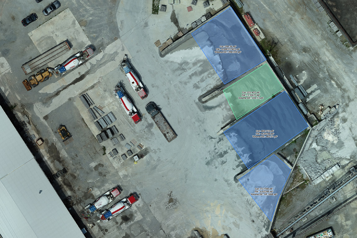
D. Earthwork Volume Calculations
- How it Works: (Briefly mentioned here, detailed in Blog 5) Drones utilize photogrammetry or LiDAR to rapidly capture the 3D geometry of stockpiles, excavation pits, or entire earthwork sites.25 Specialized software processes this data to create accurate 3D surface models.
- Benefits: Volume calculations derived from these models are significantly more accurate, faster to obtain, and safer than traditional ground survey methods.25 This improves inventory management, progress tracking for cut/fill operations, and verification for payment applications.25
- Deliverable: Volumetric Reports (Cut/Fill, Stockpile Quantities), 3D Models of site terrain/stockpiles.
IV. Actionable Insights: Leveraging SimpliFly AEC Data
SimpliFly ensures that the data collected is not just technically accurate but also presented in formats that are easily understood, integrated, and acted upon by AEC professionals.
- Deliverables Explained:
- Orthomosaics: These high-resolution, map-accurate images serve as a powerful visual base layer.9 They can be overlaid with design drawings (CAD/BIM) to instantly visualize progress or deviations. Their uniform scale allows for accurate 2D measurements of distances and areas directly on the map, unlike standard distorted aerial photos.10
- DEM/DTM/Contours: These deliverables provide a clear understanding of the site’s topography.20 Digital Elevation Models (DEMs) and Digital Terrain Models (DTMs) are fundamental inputs for site design software, enabling engineers and architects to perform critical analyses for grading, drainage, visibility, and earthwork calculations. Contour lines offer a familiar visual representation of elevation changes.41
- LiDAR Point Clouds: These datasets consist of millions or even billions of individual points, each with precise X, Y, Z coordinates.30 Visualization software allows users to navigate these 3D point clouds, color-code them by elevation or intensity (laser return strength), slice through them to create cross-sections, and measure distances between points with high precision.45 They provide an incredibly detailed digital replica of the scanned environment.
- 3D Models: Generated from photogrammetry or LiDAR, these models offer a realistic, navigable 3D representation of the site or structure.14 They are invaluable for visualization, stakeholder communication, virtual site walk-throughs, and, when integrated with BIM, for clash detection between different building systems.
- Inspection Reports: These reports go beyond raw images. They typically include annotated photos or video clips highlighting specific defects or areas of concern, along with descriptions, location information, and severity assessments, providing a clear action list for maintenance or repair teams.34
- Data Integration: A key aspect of SimpliFly’s service is providing data in formats readily compatible with the software tools AEC professionals already use, such as AutoCAD, Civil 3D, Revit, ArcGIS, and various construction management platforms.14 This seamless integration ensures that drone-derived data enhances existing workflows rather than requiring cumbersome conversions or separate processes.21
The frequent, objective data captured by drones establishes a crucial “single source of truth” regarding the physical state of the project site. In complex projects involving multiple stakeholders (owners, designers, engineers, contractors, subcontractors), differing interpretations of progress or site conditions based on outdated or incomplete information can lead to disputes and delays. Drone data provides a shared, verifiable record that minimizes ambiguity, aligns understanding across teams, and facilitates fact-based decision-making.22
Furthermore, the value of this data extends far beyond the construction phase. The comprehensive digital record created through regular drone flights essentially forms a “digital twin” of the asset.14 This detailed as-built documentation, capturing everything from site topography to structural details and MEP (Mechanical, Electrical, Plumbing) installations before they are covered up, becomes an invaluable resource for ongoing facility management, future maintenance planning, condition monitoring, and planning subsequent renovations or expansions throughout the building’s entire lifecycle.16
V. The Bottom Line: Quantifying the Drone Advantage in AEC
The adoption of drone technology in AEC delivers a clear and compelling return on investment, measured not only in direct cost savings but also in significant improvements to project timelines, safety, and quality.
- ROI Data: Case studies consistently demonstrate the financial benefits. Projects incorporating drones have reported:
- Reductions in inspection times by up to 60%.24
- Labor cost savings ranging from 20% to 30%.24
- Overall project ROI improvements between 15% and 25%.24
- Specific examples include saving $90,000 on a single earthmoving job due to better takeoff reporting and saving $3,500 per day by avoiding unnecessary crew mobilization to unready sites.50
- Value Beyond Cost: The advantages extend beyond the balance sheet:
- Accelerated Project Timelines: Faster surveying, monitoring, and issue detection contribute to shorter overall project durations.24
- Enhanced Safety Records: Reducing worker exposure to hazards leads to fewer incidents and injuries.24
- Improved Quality Control: Early detection of deviations from design plans minimizes errors and ensures higher quality construction.15
- Reduced Rework: Catching mistakes before they are built upon saves significant costs associated with demolition and reconstruction.37
- Better Decision-Making: Accurate, timely data empowers project managers and engineers to make more informed decisions.20
- Improved Stakeholder Communication: Clear visual data fosters better understanding and collaboration among all parties involved.22
Strategically, the benefits of drone services are amplified when implemented early in the project lifecycle. Utilizing drones during the initial planning and design phases for accurate site analysis and topographic mapping helps optimize the design, anticipate challenges, and prevent costly errors that might only become apparent during construction.23 This proactive approach yields compounding returns by ensuring a more efficient and less problematic execution phase, ultimately impacting the project’s overall success and profitability.14
VI. Partnering with SimpliFly: Your AEC Data Experts
Navigating the complexities of drone technology, data processing, and regulatory compliance can be daunting for AEC firms looking to leverage aerial intelligence. SimpliFly offers specialized expertise and end-to-end service, making the benefits accessible without the burden of managing an in-house program.
- SimpliFly’s Approach: We possess deep expertise in the specific data requirements of the AEC industry.35 Our comprehensive services cover the full spectrum, including site surveying, topographic mapping, construction progress monitoring, structural inspections, and volumetric analysis. We utilize the most appropriate, state-of-the-art drone technology for each task, whether it requires high-resolution photogrammetry, precise LiDAR scanning, or thermal imaging, often incorporating RTK/PPK for maximum accuracy.20 Our focus is on delivering accurate, timely data in formats that seamlessly integrate into your existing workflows.12 Safety is paramount; all operations are conducted by experienced, FAA-certified pilots following strict safety protocols and regulatory compliance.12
- Why Choose SimpliFly: Establishing and maintaining an effective internal drone program involves significant challenges: high upfront costs for professional-grade drones and sensors, specialized software licenses, rigorous pilot training and certification, ongoing equipment maintenance, navigating complex and evolving FAA regulations, and developing data processing expertise.12 SimpliFly eliminates these complexities, providing a reliable, efficient, and expert partnership that allows you to focus on your core business while benefiting from the best aerial data solutions.
- Call to Action: Elevate your next project with drone intelligence. Contact SimpliFly today to discuss your specific AEC project needs and discover how our tailored aerial data solutions can enhance your accuracy, efficiency, and safety. We’re ready when you are!.12
VII. Conclusion: Building the Future with Drone Intelligence
Drones are no longer just a futuristic vision for the AEC industry; they are powerful tools actively reshaping workflows and delivering measurable results today. By providing unprecedented levels of site intelligence – from highly accurate topographic maps for design to real-time visual progress tracking and detailed structural inspections – drones empower AEC professionals to overcome traditional challenges, mitigate risks, and achieve greater project success. SimpliFly serves as the crucial link, translating advanced aerial technology into actionable data and insights that drive smarter planning, safer execution, and more efficient construction. As the technology continues to advance with automation, AI-driven analytics, and deeper BIM integration 16, partnering with experts like SimpliFly will be key to staying ahead and building the future more intelligently.